

At 11:30 this morning, the weather system now called a deep depression sat in the Bay of Bengal, about 870 km out to sea from Visakhapatnam. The India Meteorological Department (IMD) expects it to become Cyclone Arnab by Monday morning and to make Cyclone Arnab landfall on the Andhra Pradesh coast on the forenoon of Wednesday, 28 October, with winds of up to 140 km/h in gusts.
So it’s not surprising that “cyclone Arnab tracker”, “landfall date” and “red alert meaning” are among the top searches in India right now. Here’s what the official forecast actually says, what the colour-coded alerts mean, and a simple checklist to get your home and family ready.
Quick answer
- Where: IMD expects Arnab to cross the Andhra Pradesh and Yanam coasts between Bapatla and Visakhapatnam.
- When: By the forenoon of 28 October 2026, as a very severe cyclonic storm with winds of 115–125 km/h, gusting to 140 km/h.
- Who else is affected: Very heavy rain is forecast for coastal Andhra Pradesh and Odisha, then east Telangana, Chhattisgarh and parts of central and east India on 28–30 October.
- Kerala: Its heavy rain comes from a separate low in the Arabian Sea.
- What to do now: Charge phones, pack an emergency kit, keep documents in waterproof covers, and follow only official alerts.
Cyclone Arnab landfall: where and when it is expected
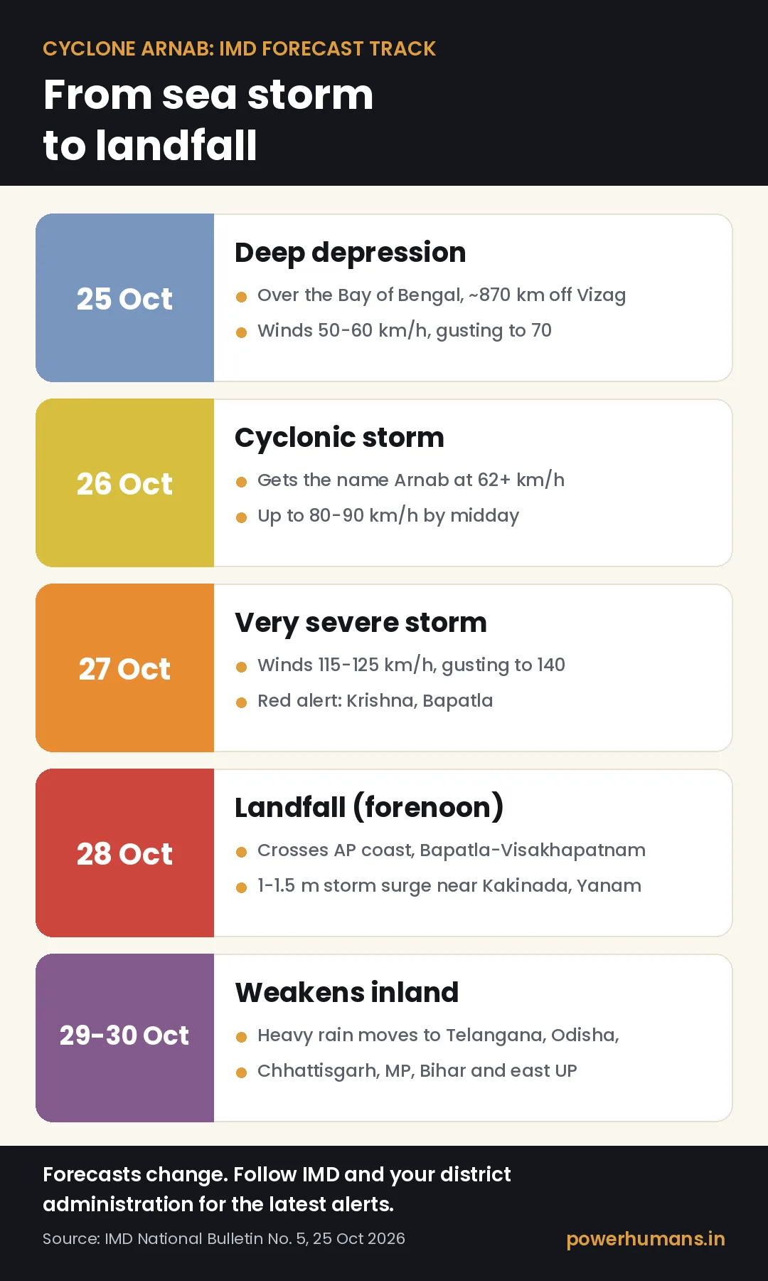
According to IMD’s National Bulletin No. 5, issued at 3:15 pm IST on 25 October, the deep depression was crawling southwest at just 5 km/h. It is then expected to turn west-northwest and strengthen in steps:
- 26 October, early morning: becomes a cyclonic storm and gets the name Arnab.
- 27 October, morning: becomes a severe cyclonic storm over the west-central Bay of Bengal, and then a very severe cyclonic storm.
- 28 October, forenoon: crosses the coast between Bapatla and Visakhapatnam with sustained winds of 115–125 km/h, gusting to 140 km/h.
- 29–30 October: weakens over land into a depression and then a low-pressure area, with the rain moving north.
IMD also warns of a storm surge of 1 to 1.5 metres above the normal tide, which could flood low-lying areas near Kakinada and Yanam at the time of landfall. Fishermen have been told to stay off the sea, and IMD has advised a total suspension of fishing operations in the affected areas.
The exact landfall point and timing can still shift, so treat social media “live trackers” as a rough guide and check IMD’s own bulletins (mausam.imd.gov.in), updated several times a day. For more explainers on the news everyone is searching for, see our Trending India explainers.
Which states and districts are on alert
Andhra Pradesh and Yanam
The Hindu reports red alerts for Krishna and Bapatla districts on 27 October, and for 12 districts including Visakhapatnam, Kakinada, Konaseema, East and West Godavari, Guntur and Bapatla on 28 October. The Andhra Pradesh State Disaster Management Authority (APSDMA) has said people in low-lying areas and kutcha houses from Bapatla to Vizianagaram will be moved to shelters. The state has 12 SDRF and 7 NDRF battalions ready and has asked for three more NDRF battalions.
Odisha, Telangana and beyond
IMD forecasts extremely heavy rain at isolated places in Odisha, eastern Telangana and south Chhattisgarh on 28 October. As the system moves inland, heavy rain is expected in parts of Vidarbha, east Madhya Pradesh, Jharkhand, Bihar, east Uttar Pradesh and West Bengal until 30 October.
Why Kerala is getting heavy rain too
Kerala is not in Arnab’s path, but a separate low-pressure area over the southeast Arabian Sea is bringing heavy rain. Red alerts were in force for Malappuram, Kozhikode and Wayanad on 25 October, and collectors there declared holidays for educational institutions. An IMD alert doesn’t close schools by itself; only the district collector’s order does.
Red, orange or yellow alert: what each colour means
IMD uses four colours so that people and officials can react quickly:
- Green: no warning, no action needed.
- Yellow (be aware): bad weather is possible; stay updated. For rain, it means heavy rainfall of roughly 7–11 cm in 24 hours.
- Orange (be prepared): expect disruption to travel, power and daily life. For rain, roughly 12–20 cm in 24 hours.
- Red (take action): a threat to life and property. For rain, more than 20 cm in 24 hours. Avoid travel and follow official instructions.
It’s the same idea as the colour bands on an air-quality reading. If you live in north India and are dealing with smog instead of storms this week, our guide on how to protect your lungs during smog season explains those AQI colours too.
Cyclone watch, alert and warning
For cyclones, IMD’s standard procedure has four stages: a pre-cyclone watch about 72 hours before bad weather, a cyclone alert at least 48 hours before, a cyclone warning at least 24 hours before, and a post-landfall outlook at least 12 hours before landfall. Today’s bulletin is a cyclone alert for Andhra Pradesh and south Odisha.

How to prepare for Cyclone Arnab: a step-by-step checklist
These steps are based on the do’s and don’ts published by the National Disaster Management Authority (NDMA) and APSDMA.
Before it arrives (now to 27 October)
- Charge everything. Keep phones and power banks full, and note down key numbers on paper in case your battery dies.
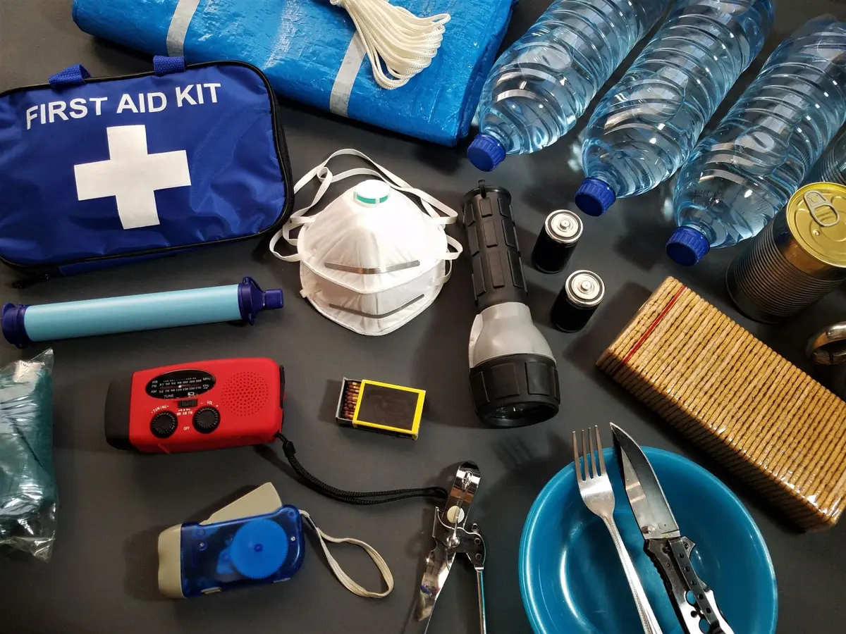
- Pack an emergency kit. Include a torch, spare batteries, medicines, a first-aid kit, ready-to-eat food and enough drinking water for several days.
- Protect your documents. Put Aadhaar, voter ID, passports, property papers and certificates in a waterproof bag. (Replacing lost papers is a headache; ask anyone who has had to check their name on the voter list and fix their records.)
- Secure your home. Repair loose roof sheets and tiles, tie down or bring in anything that can fly, and trim dead branches near the house.
- Know your shelter. If you live near the coast or in a kutcha house, find out where your nearest cyclone shelter is and how to reach it before the roads flood.
- Plan for pets and livestock. NDMA advises keeping cattle and animals untied so they can escape danger. Many of the same rules from our guide to preparing pets for travel help if you must take a pet to a shelter.
During the storm
- Stay indoors and keep doors and windows shut. Switch off the electrical mains and the gas connection.
- Don’t be fooled by a sudden calm. If the eye of the storm passes overhead, winds can return from the opposite direction. Wait for the official all-clear.
- If you’re outside, never shelter under trees, electric poles or hoardings, and don’t enter damaged buildings.
- Drink only boiled or chlorinated water.
After it passes
- Stay away from fallen wires and damaged poles. In north coastal Andhra, APEPDCL asks people to report power problems on its toll-free helpline, 1912.
- Don’t go back home from a shelter until officials say it’s safe.
- Get damaged electrical equipment checked by an electrician before you switch it on.
- Look after yourselves. Disasters are stressful, especially for children and older relatives. Simple routines from our self-care guide can help everyone settle down afterwards.
Emergency numbers in Andhra Pradesh: APSDMA lists 112, 1070 and 1800-425-0101 for its 24-hour State Emergency Operations Centre.
Why is it called Arnab?
The name was proposed by Bangladesh and, according to the World Meteorological Organization’s list, is pronounced “Ornab”. Cyclones in the Bay of Bengal and the Arabian Sea are named by IMD’s regional centre in New Delhi from a list agreed by 13 countries: Bangladesh, India, Iran, the Maldives, Myanmar, Oman, Pakistan, Qatar, Saudi Arabia, Sri Lanka, Thailand, the UAE and Yemen.
A system is named only once its sustained winds reach 62 km/h, which is why today’s deep depression doesn’t have a name yet. Names are used in order down the list, and once a name has been used it is never repeated.
Want to do your bit for the planet once the storm passes? Start with our simple steps to a more sustainable life.
FAQ
When will Cyclone Arnab make landfall?
IMD’s 25 October bulletin expects landfall on the Andhra Pradesh and Yanam coasts between Bapatla and Visakhapatnam by the forenoon of 28 October 2026. The timing may change, so check the latest IMD update.
Will Cyclone Arnab hit Chennai or Kerala?
Neither is in the forecast path. North Tamil Nadu’s coast may see squally winds on 27–28 October. Kerala’s heavy rain comes from a separate low-pressure area in the Arabian Sea.
How strong is Cyclone Arnab expected to get?
It’s forecast to become a very severe cyclonic storm, the category for sustained winds of 118–166 km/h on IMD’s scale. At landfall, IMD expects winds of 115–125 km/h, gusting to 140 km/h.
Where can I track Cyclone Arnab live?
Use IMD’s official website and the Mausam app, your state disaster management authority, and SMS alerts on your phone. Don’t forward unverified videos or rumours.
The takeaway
Cyclone Arnab is forecast to be a serious storm for coastal Andhra Pradesh, with heavy rain spreading to several other states. The forecast gives families two clear days to prepare. Charge your phones, pack a kit, protect your papers, know where your shelter is, and trust only official alerts. If you have relatives on the coast, share this checklist with them today.
Related reads
- Why Your Throat Burns Every October: 9 Smog-Season Habits That Actually Protect Your Lungs
- SIR Explained: Why India’s Voter Lists Are Being Rechecked and How to Find Your Name
- Living Green: Simple Steps to a More Sustainable Life
Sources
- India Meteorological Department: National Bulletin No. 5 (BOB/08/2026), 25 October 2026
- The Hindu: Andhra Pradesh braces for very severe cyclonic storm
- The Hindu: People in low-lying areas from Bapatla to Vizianagaram to be evacuated
- The Hindu: APEPDCL puts 12 coastal districts on high alert
- Mathrubhumi: Cyclone Arnab alert and the Kerala rain warning
- Mathrubhumi: Kerala rain alerts and school holidays
- Kerala Kaumudi: Holidays declared in three districts
- Hindustan Times Telugu: APSDMA cyclone guidelines and helpline numbers
- IMD: Cyclone Warning in India, Standard Operating Procedure
- IMD RSMC New Delhi: Frequently asked questions on tropical cyclones
- World Meteorological Organization: Northern Indian Ocean cyclone names
- National Disaster Management Authority: Cyclone do’s and don’ts
- Business Standard: IMD’s colour-coded alerts explained






Leave a Reply